Mapping the world in Three-Dimension
Author: Neuvition, IncRelease time:2020-07-21 10:17:53
Backgroud:
As the next change the way of human life, blue ocean technology, unmanned vehicle research increasingly received high attention from academia and industry, the technology involved in cognitive science, artificial intelligence, control science, engineering machinery, such as the cross subject, is the best test platform for all kinds of emerging technologies, but also to the inevitable trend of future development. In the research field of driverless cars, how to realize the environment modeling of 3d scene completely, accurately and in real time has always been the focus and difficulty of the research. In the field of unmanned vehicle, multi-line LiDAR has the following two core functions: 3D modeling and environment perception: Multi-line LiDAR can be used to scan the 3D model of the surrounding environment of the car, and relevant algorithms can be used to compare the changes of the environment in the previous frame and the next frame, so as to detect the surrounding vehicles and pedestrians more easily.
Principle:
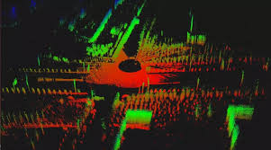
By measuring the time difference and phase difference of the laser signal, LiDAR determines the distance, measures the Angle by horizontal rotation scanning or phase control scanning, and establishes a 2D polar coordinate system according to the above data.Then the height information of the 3D is obtained by acquiring signals of different pitch angles. A high frequency laser can obtain a large amount of position point information in one second and conduct 3D modeling based on this information. In addition to obtaining location information, LiDAR can distinguish different materials by the reflectivity of laser signal.
The main advantage of LiDAR is that it can model the surrounding objects and form high-resolution 3D images, so that the computer can quickly identify and make decisions.
Advantages:
To form high-resolution 3D images of surrounding objects;
Detect long range;
Work from day and night, no need to use the external light.
Challenge:
Could not use in heavy fog and smoke environment.
High cost.
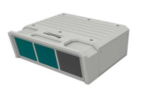
By means of high-speed laser scanning, Neuviton Titan M1-A products can obtain array geometric image data of objects or terrain surfaces in the form of point cloud, and users of Titan M1-A can easily obtain accurate 3D file data at different times and places without damaging their eyes.
Advantange:
High Angular resolution, collect 1.5 million point cloud per second;
1550nm wavelength, penetrate the heavy fog and smoke;
Life spam with 5W hours;
Precision within ±5mm.