
Truck and load volume
Scan open-top bulk trucks carrying coal, sand, gravel, aggregate, ore, soil or similar materials where volume records matter.
Neuvition delivers complete bulk truck cargo volume scanning solutions for mines, ports, quarries, stockyards and logistics yards—linking LiDAR scans, ANPR evidence and usable volume records.
For mines, ports, quarries, stockyards and logistics yards, the goal is not only to scan a truck. A practical system helps reduce manual disputes, standardize load records, and connect measurement evidence with settlement, audit or daily operation workflows.
LiDAR scan results can be linked with vehicle identity, timestamp, site images and transaction records so teams can review how each volume result was produced.
Neuvition combines LiDAR sensing, point-cloud processing, ANPR evidence, measurement software and deployment support as one solution path.
Your team can specify the usable outputs it needs: volume records, image evidence, database entries, PDF / CSV reports, or API / ERP inputs.
Scan open-top bulk trucks carrying coal, sand, gravel, aggregate, ore, soil or similar materials where volume records matter.
Compare loaded-truck and empty or reference profiles to calculate cargo volume with less dependence on manual visual estimation.
Link point-cloud measurement with license-plate recognition, site images and transaction records for traceable review.
Use volume results for on-screen review, local records, exported reports, database storage, or API / ERP integration when required.
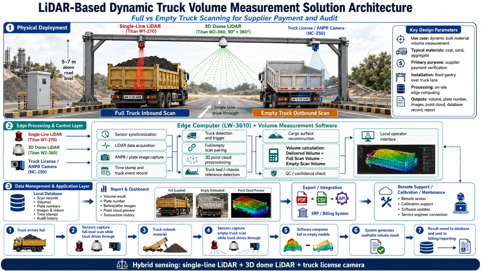
When delivered volume affects supplier settlement or operational reconciliation, manual estimates and disconnected records are often not enough. Neuvition combines scan-lane sensing, full/empty comparison, license-plate evidence and software output so the result can be reviewed and used beyond the measurement point.
Truck type, material, lane layout, unloading process, daily traffic volume, accuracy expectation and report / ERP output help determine the recommended system setup.
Request an application review →A fixed scan lane helps capture repeatable truck, cargo-surface and license-plate data as vehicles enter or leave the operation.
Loaded and empty or reference scans help calculate delivered volume and reduce dependence on visual estimation or supplier-declared figures.
On-site software processes point clouds and prepares measurement results that operators can review before records are used downstream.
Each record can carry plate, time, image and point-cloud evidence, then support reports, CSV/API export or ERP / billing integration.
Each project can be planned around the records your team needs for daily operation, supplier settlement, audit review and management reporting.
If volume records need to enter another system, Neuvition can align data format, transfer method and interface scope with your engineering team.
For sites that need more than standalone reporting, planning usually covers SDK access, Ethernet communication, real-time data handling and whether robotics or autonomous-system support is required.
Share integration requirements →Neuvition provides C/C++ SDK support for LiDAR product integration. Other programming-language or special interface requirements can be reviewed during solution planning.
LiDAR data communication is mainly based on Ethernet, helping teams plan network layout, edge computing equipment and site-side connections.
SDK support can be relevant for real-time data access, moving platforms, autonomous vehicles or other time-sensitive industrial scenarios.
For robotics or autonomous-system projects, Neuvition can review SDK and ROS driver support with the customer engineering team.
Evaluation hardware, development kits and integration support packages can be confirmed by LiDAR model, location and technical support scope.
You do not need to know the final technical setup. If the basic site scenario matches, Neuvition can assess whether LiDAR truck volume measurement is practical for your operation.
Your site information helps determine whether LiDAR truck-volume measurement is relevant and what system setup may be appropriate.
Material type, truck workflow, site photos and output needs.
Neuvition reviews whether scanning and ANPR matching fit.
Align sensor package, lane concept and software output.
Prepare a relevant demo, recommendation or quotation.
Move toward calibration, installation and integration planning.
Use these questions to check whether LiDAR truck volume measurement is relevant to your site and what information can help Neuvition prepare a useful recommendation.
If you handle open-top bulk trucks and need repeatable volume records, this solution is likely worth evaluating.
Material type, truck dimensions, site photos, lane conditions, daily truck volume, output format, and ERP/billing/weighbridge needs.
No. Share the site scenario first. Neuvition can assess application fit and recommend a suitable sensor/software setup.
Neuvition provides LiDAR-based industrial solutions with experience in real-world application scenarios. Its team combines LiDAR hardware knowledge, point-cloud algorithms, multi-sensor fusion and system integration support to help customers evaluate a practical solution based on actual site conditions.
Yes. The system can associate volume results with license plate, timestamp, images, point-cloud view and transaction reports.
Neuvition can review the scenario, clarify site conditions, assess feasibility and prepare a relevant demo, recommendation or quotation.
Tell us about your site scenario, target task, installation condition, and required data output. Our team can help evaluate the right LiDAR sensor setup, point-cloud workflow, and deployment approach for your project.
Submit your application requirement and Neuvition will follow up with a practical recommendation.
 Industry Application Video
 Solution Walkthrough